The Bottom of the Atlantic, the fourth section of Chapter VII of Immanuel Velikovsky’s Earth in Upheaval, is one of the most frequently cited passages in the whole book. In these three pages or so Velikovsky presents geological evidence that cannot possibly be explained in the gradualist terms of the Uniformitarians. The catastrophist would be hard-pressed to build a case for his side than that which Maurice Ewing has done here.
In the fall of 1949, Professor M. Ewing of Columbia University published a report on an expedition to the Atlantic Ocean. Explorations were carried on especially in the region about the Mid-Atlantic Ridge, the mountainous chain that runs from north to south, following the general outlines of the ocean. The Ridge, as well as the ocean bottom to the west and to the east, disclosed to the expedition a series of facts that amounts to “new scientific puzzles.” (Velikovsky 92)
William Maurice Ewing was an American geophysicist and oceanographer. He was born in Texas in 1906, and studied physics at Rice University, Houston, in the 1920s. He was awarded his PhD in 1931, the subject of his thesis being seismology. Between 1930 and 1940 he taught physics at Lehigh University in Bethlehem, Pennsylvania. It was here that he developed an interest in geophysics—particularly the application of explosives and seismology to prospecting. In 1934 two colleagues suggested that he apply these techniques to the study of the continental shelf. Thus began a new career for Ewing, one which would see him participate in more than fifty oceanographic expeditions.
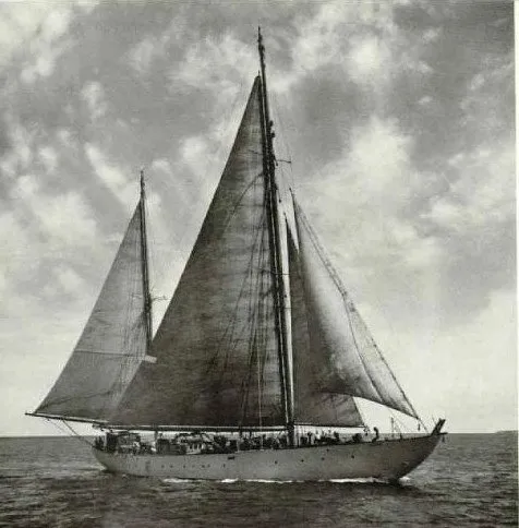
The expedition we are interested in—Cruise 150—took place in the summer of 1947, the year Ewing was appointed Professor of Geology at Columbia University, in New York. This was Ewing’s first expedition to the Mid-Atlantic Ridge. The expedition was carried out in a 45-metre steel-hull ketch, Atlantis, the Woods Hole Oceanographic Institution’s first research vessel. The pioneering use of the fathometer on this expedition allowed Ewing and his associates to create the world’s first accurate map of an abyssal plain.
In 1948 and 1949 two popular articles by Ewing (and photographer Robert F Sisson) were published in the National Geographic Magazine. Both articles can be read at the Internet Archive. It is the second of these that Velikovsky cites in this section. Ewing and his colleague Ivan Tolstoy also co-wrote a peer-reviewed paper on the same expedition, which was published by the Geological Society of America in 1949. This too can be accessed on the Internet Archive.
Velikovsky quotes Ewing on the first of his “new scientific puzzles”:
Some of the things we found on this second cruise create new scientific puzzles. One was the discovery of prehistoric beach sand in two core samples of the bottom, brought up in one case from a depth of two [3.2 km] and in the other nearly three and one-half miles [5.6 km], far from any place where beaches exist today.
In one core there were actually two layers of sand, one 20,000 to 100,000 years old and the other 225,000 to 325,000, these ages being calculated from the depth and the average rate at which sediment is deposited. (Ewing 1949:612-613)

Ewing proposes two “startling theories” to explain the presence of this sand:
Sometime in the distant past this sand found deep beneath the ocean must have been located on a beach, at or near the surface of the sea. Either the land must have sunk two to three miles [3-5 km], or the sea once must have been two to three miles lower than now.
Either conclusion is startling. If the sea was once two miles lower, where could all the extra water have gone? (Ewing 1949:613)
Ewing rejects the possibility that the sand was created far from where it is now found:
Some sand found in other places on the Atlantic bottom undoubtedly was rafted out from shore by floating ice during past glacial periods. Such sand is well mixed with larger rock fragments.
But the grains in the sand we found are well sorted into various sizes, with no large fragments. This fact suggests that here is a real beach, unless the sand was originally picked up from a beach by ice, which is extremely unlikely.
One of these sand deposits is 1,200 miles [2000 km] from land and so far south that it is impossible that ice could ever have carried sand that far before melting. (Ewing 1949:613)

It is not surprising that catastrophists are so fond of this section of Earth in Upheaval. Tolstoy & Ewing also refer to this beach sand in their paper that appeared in the same year as the article in The National Geographic Magazine:
During cruise 150 the ATLANTIS obtained a core 20 miles [32 km] southeast of this mount [Caryn Seamount]. It showed coarse quartz sand stratifications in the upper section of the core, This sand is now being studied by D. Ericson. Recent (Trask, Phleger, and Stetson, 1947) investigation has shown the presence of sand in the deep basin of the Gulf of Mexico. More recent cruises of the ATLANTIS have found sand at depths of many feet in various parts of the North American basin. The presence of these sands poses one of the most baffling problems of submarine geology. (Tolstoy & Ewing 1532)
Maurice Ewing was no catastrophist. Despite the fact that the ship that carried out several of his oceanographic expeditions bore the name Atlantis, Ewing was bitterly opposed to the hypothesis that there had once been a large landmass in the Atlantic Ocean.
Ever since its discovery 75 years ago, this ocean-covered mountain range of continental size has stirred the imagination of men in many lands. Romanticists inevitably connect the Ridge with the legend of the lost Atlantis, the mythical Atlantic continent which Plato related sank beneath the waves in a single day and one fatal night.
Though our ship was named Atlantis, we had no illusions of solving that age-old mystery story. (Ewing 1948:275)
It is ironic, therefore, that he should have provided catastrophists with such strong evidence for the lost continent.

Oceanic Sediments
Velikovsky now turns to another startling discovery made by the Atlantis:
But there was another surprise in store for the expedition. The thickness of the sediment on the ocean bottom was measured by the well-developed method of sound echoes. An explosion is set off and the time it takes for the echo to return from the sediment on the floor of the ocean is compared with the time required for a second echo to return from the bottom of the sediment, or from the bedrock, basalt or granite. “These measurements clearly indicate thousands of feet of sediments on the foothills of the Ridge. Surprisingly, however, we have found that in the great flat basins on either side of the Ridge, this sediment appears to be less than 100 feet thick, a fact so startling ...” Actually, the echoes arrived almost simultaneously, and the most that could be attributed in such circumstances to the sediment was less than one hundred feet of thickness, or the margin of error. (Velikovsky 93)
The full passage from which Velikovsky quotes reads as follows:
In more than 3,000 different places over vast areas of the Atlantic we have now measured with sound echoes the depth of the sediment on top of the bedrock of the ocean floor. These measurements clearly indicate thousands of feet of sediments on the foothills of the Ridge. Surprisingly, however, we have found in the great flat basins on either side of the Ridge this sediment appears to be less than 100 feet [30 m] thick, a fact so startling that it needs further checking. (Ewing 1949:614)

These ocean-bottom sediments we measured are formed from the shells and skeletons of countless small sea creatures that die and sink year after year; from volcanic dust and wind-blown soil drifting out over the sea; and from the ashes of burned-out meteorites and cosmic dust from outer space sifting constantly down upon the earth.
Near the coast, where much material from land is carried out into the water, one or two feet [0.5 m] of sediment may be deposited on the ocean floor in 1,000 years, but farther out near midocean only half an inch [1 cm] may be laid down in the same length of time. This is known from the age of fossils found in the mud and the amount of radium in various layers, which is also a measure of age.
Always it had been thought the sediment must be extremely thick, since it had been accumulating for countless ages, like snow in Arctic areas. But on the level basins that flank this Mid-Atlantic Ridge our signals reflected from the bottom mud and from bedrock came back too close together to measure the time between them. These echoes are complicated, but we think are reading them correctly and that they show the sediment in the basins is less than 100 feet thick! (Ewing 1949:616)
Ewing also made some anomalous discoveries closer to the Ridge:

Sediments seem to be thin, too, on the upper highlands of the Mid-Atlantic Ridge. But on the flanks of the Ridge, its terraces and foothills, are layers of sediment in some places thousands of feet thick, as was expected. Perhaps submarine currents have swept it off the highlands down upon the lower areas, but this would not explain the absence of thick sediment on the level plains. Here is another of the many scientific riddles our expedition propounded. (Ewing 1949:617)
The seafloor close to the Ridge is geologically young—much younger than the seafloor in the abyssal plains. We would expect, therefore, to find thin sediments close to the Ridge and thick sediments in the abyssal plains.
Velikovsky next asks a question:
Burned-out meteorites and cosmic dust elicited the question: If the meteoric dust in our age is so sparse that it is hardly detectable on the snow of high mountains, how could ashes of burned-out meteorites and cosmic dust make up a substantial part of the oceanic sediment? And how could it be that all other sources, including detritus carried by rivers, have created hi all ages since the beginning a sediment of only very moderate thickness? (Velikovsky 94)
But nowhere in his article does Ewing claim that meteoritic dust comprises a substantial part of the oceanic sediment.

Igneous and Sedimentary
The igneous nature of the Mid-Atlantic Ridge, which Ewing confirmed, is now well known. This is a natural consequence of the important rôle the Ridge plays in plate tectonics and seafloor spreading. What was not expected, however, was evidence of relatively young sedimentary rocks:
Dredging the eastern flank of the steep ridge running along the northwest edge of the 2100-fathom [3.8 km] terrace at point G of Plate 7 [32° 03' N 42° 16' W] brought up a large block of manganese-encrusted limestone of probably Cenozoic age ...
One of the big surprises of the 1947 ATLANTIS expedition (cruise 150) was the proof of the existence of consolidated Cenozoic limestone on the Mid-Atlantic Ridge. Possibly considerable areas of the Ridge consist of sedimentary rocks. If so, the hypothesis of folded ranges in certain parts of the Ridge should not be rejected arbitrarily, on the sole basis that it is difficult in the light of our scanty knowledge of the history of the earth’s crust to explain the why and how of such a process. It must be disproved by experimental and observational data; until then it remains a possibility. (Tolstoy & Ewing 15337 ... 1539)
Hudson Canyon
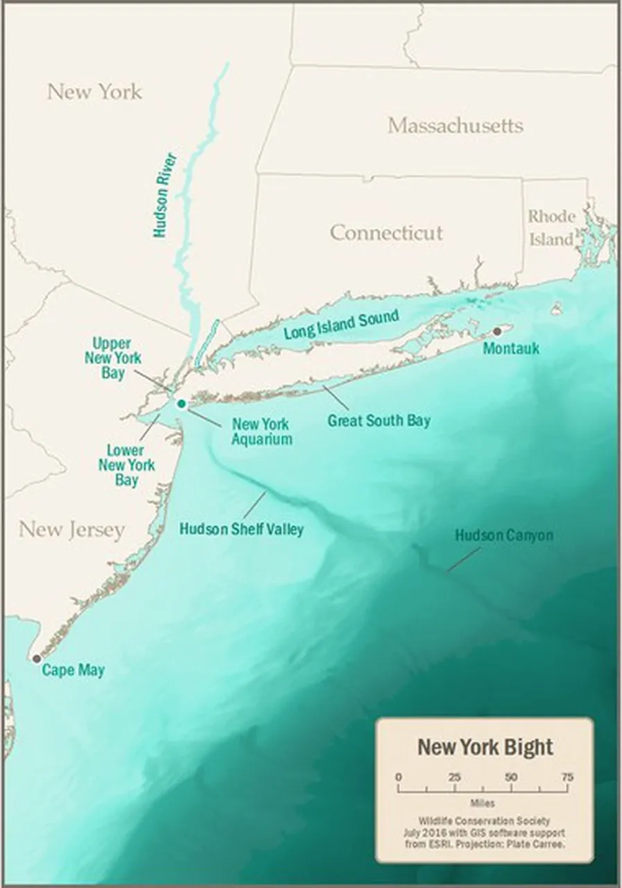
Another remarkable discovery of the Atlantis expedition was made off the coast of New York:
An interesting recent discovery made with our fathometer was that the submerged canyon of the Hudson River, a continuation of the Hudson Valley, extends 100 miles [160 km] farther out under the sea than anyone had known before. Several years ago the Hudson Valley was charted out under water to the edge of the continental shelf, 120 miles offshore [200 km].
But on this trip our fathometer found a slight dip even farther out. We have now traced this canyon for another 100 miles [160 km] across a lower, second slope on the edge of the continent, in water one and a half to two and a half miles deep. Here the valley is two to three miles wide and 300 to 1800 feet [100-600 m] below the level of the shelf through which it cuts.
If all this valley was originally carved out by the river on dry land, as seems probable, it means either that the ocean floor of the eastern seaboard of North America once must have stood about two miles above its present level and has since subsided, or else that the level of the sea was once about two miles lower than now. (Ewing 1949:614)
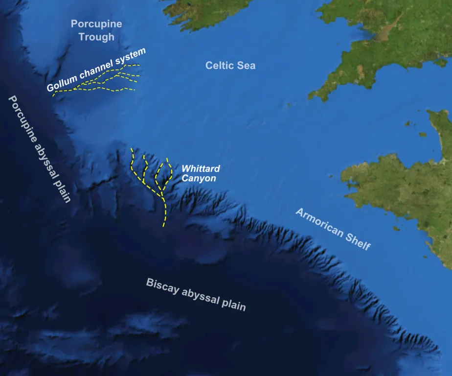
Similar submarine canyons have been subsequently discovered on other continental slopes, confirming Ewing’s observation that sea level during the last Ice Age must have been much lower than is generally claimed. Modern Uniformitarians have tried to avoid this unsavoury conclusion by attributing these canyons to other processes, such as turbidity currents or slumping.
Velikovsky concludes this section by doing what Ewing refused to do: acknowledging the obvious evidence here of recent catastrophism:
All in all, the results of the expedition of the summer of 1949 strongly indicate that, at some time not so long ago, in numerous places where the Atlantic Ocean is today there were land and beaches, and that in revolutions on a great scale land became sea thousands of fathoms deep. The leader of the Atlantis expedition, whom we have quoted here, did not use the term “revolution,” but it is unavoidable in the face of the expedition’s finds. In order not to be regarded as the proponent of a heresy, Ewing made only a negative statement: “There is no reason to believe that this mighty underwater mass of mountains is connected in any way with the legendary lost Atlantis which Plato described as having sunk beneath the waves.” (Velikovsky 95)
In his Atlantis articles Ewing’s only response to the litany of new puzzles uncovered is to call for further research:
... it needs further checking. (Ewing 1949:614)
More than seventy years have now elapsed since Maurice Ewing’s epochal Atlantis expeditions. In that time, what theories have the Uniformitarians come up with to resolve Ewing’s many puzzles? With the exception of the submarine canyons, none to my knowledge. I do not even think any oceanographers have returned to the Mid-Atlantic Ridge in an attempt to either confirm or refute Ewing’s original findings.
How long must these puzzles be left unsolved?

And that’s a good place to stop.
References
- Edward Crisp Bullard, William Maurice Ewing, Biographical Memoirs of Fellows of the Royal Society, Volume 21, Pages 268-311, The Royal Society Publishing, London (1975)
- Maurice Ewing, Exploring the Mid-Atlantic Ridge, The National Geographic Magazine, Volume 94, Number 3, Pages 275-294, National Geographic Society, Washington, DC (1948)
- Maurice Ewing, New Discoveries on the Mid-Atlantic Ridge, The National Geographic Magazine, Volume 96, Number 5, Pages 611-640, National Geographic Society, Washington, DC (1949)
- Ivan Tolstoy & Maurice Ewing, North Atlantic Hydrography and the Mid-Atlantic Ridge, Bulletin of the Geological Society of America, Volume 60, Number 10, Pages 1527-1540, The Geological Society of America, Boulder, Colorado (1949)
- Immanuel Velikovsky, Earth in Upheaval, Pocket Books, Simon & Schuster, New York (1955, 1977)
Image Credits
- Maurice Ewing on Atlantis: Edward Crisp Bullard, William Maurice Ewing, Biographical Memoirs of Fellows of the Royal Society, Volume 21, Between Pages 269 & 270, The Royal Society Publishing, London (1975)
- RV Atlantis: Robert F Sisson (photographer), The National Geographic Magazine, Volume 94, Number 3, Page 276, National Geographic Society, Washington, DC (1948), Fair Use
- Ivan Tolstoy: © Jim McEwan (photographer), Daily Record, Fair Use
- 1949 Route of the RV Atlantis: Theodora P Thompson & Irvin E Alleman (illustrators), The National Geographic Magazine, Volume 96, Number 5, Page 615, National Geographic Society, Washington, DC (1949), Fair Use
- Basaltic Pillow Lava on the Mid-Atlantic Ridge: MARUM Research Facility, University of Bremen, Fair Use
- Sediments Accumulating on the Mytilus Seamount: Mytilus Seamount, Atlantic Ocean, NOAA Photo Library, Creative Commons License
- Schematic Representation of a Seamount: © ixtract GmbH (creators), National Geographic, Fair Use
- Hudson Canyon: © Wildlife Conservation Society (creator), Fair Use
- Submarine Canyons on Europe’s Continental Slope: NASA WorldWind Software, Mike Norton (creator), Creative Commons License
- Maurice Ewing at Columbia University in 1951: Manny Warman (photographer), Columbia University (1951), Public Domain