This is the first post of the SoCal Steemit Fire Report. The main goal is to provide information about the numerous fires during fire season. Additionally, our mission is to report any natural disasters and provide a hub for supporting any steemian displaced by a natural disaster in Southern California
Intro: They say do something you are good at, well Sothern California is good at catching on fire. So we at @socalsteemit would like to provide a centralized hub of the information on fires and natural disasters located in SoCal. Com'on people! keep those burning sticks in your car and put out those campfires when you are done. Hopefully, someday we won't have to post as much on un-natural disasters. Really, I am just waiting for the robot drones to start putting out our fires. I have included the cities close to major fires in the tag section. If you have pictures, information or just want to help please stop by in our discord channel.
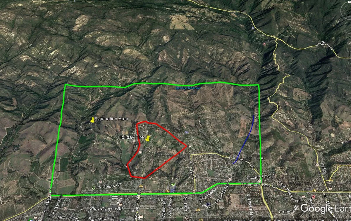
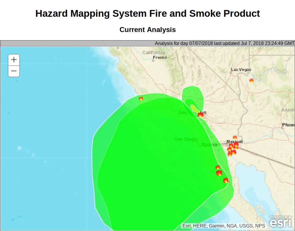
The major fires in our area are the Holiday Fire, Valley Fire, and Box Fire. Holiday Fire it is located in the hills North-West of Santa Barbra. San Bernardino has three fires the ValleyFire is a big one. I have posted a smoke map to show the origins of the smoke in the area. Stay safe ya'll.
Working on a picture for SoCal Fire Report. Does anyone want to help?
Fires and info in the SoCal region.
Name: Holiday Fire

Location: Santa Barbara County. Off north Fairview Ave and Holiday Hill Road, City of Goleta
PIO (public information officer): https://twitter.com/EliasonMike
Managing Unit: Santa Barbara County Fire
Started: July 6, 2018, 8:40 pm
Info:
80% contained
100 acres burned
https://twitter.com/EliasonMike/status/1015738212365447168
- EliasonMike
Mandatory Evacuations remain
2,500 people evacuated
Excessive heat warning today with low wind speed
Cause of the fire unknown
500 firefighters and 30 fire engines are on scene
Law enforcement in the area at roadblocks
Air quality measurements reported some elevation overnight but moderate at this time. Conditions can change. Public must take precautions to protect themselves. People in the impacted area should refrain from going outside.
160 animals in shelter
or assistance with animal evacuations, call (805) 681-4332.
Large animals are being accepted at Earl Warren Showground and at County Animal Services and the Humane Society, 5473 Overpass Road.
Small animals are being accepted at County Animal County Animal Services and the Humane Society, 5473 Overpass Road.
Link
Links:
https://readysbc.org/holiday-fire/
http://cdfdata.fire.ca.gov/incidents/incidents_details_info?incident_id=2115
http://www.ksby.com/story/38591395/firefighters-battle-goleta-rapidly-growing-vegetation-fire
Name: Box Fire
Location: 15N @ Kenwood Ave 34.244 latitude, -117.426 longitude
PIO: zbehrens@fs.fed.us
Managing Unit: Gamboa, USFS
Started: July 6, 2018 9:36 am
Info:
BoxFire Update (Cajon Pass):
- 100 acres, 50% contained
- 105 personnel
- All lanes of northbound I-15 are scheduled to reopen by 9 pm (shoulder closed in fire area)
- 8 heat-related injuries
Link
Cause of the fire was a Vehicle Fire. Currently, there are no mandatory or voluntary evacuations in place. Planned Actions for the fire are to continue to monitor for embers and hot spots.
Links:
http://cdfdata.fire.ca.gov/incidents/incidents_details_info?incident_id=2110
https://twitter.com/SBCOUNTYFIRE
Name: Valley Fire

Link
Location: Highway 38 at Valley of the Falls Drive.
PIO: bdffireinfo@fs.fed.us
Managing Unit: CALFIRE and SB County Fire
Started: July 06, 2018 1:29 pm
Info:
Current Situation: Several thunderstorms have passed through the area of the Valley Fire, and firefighters are reporting that flooding and debris flows are occurring along Valley of The Falls drive. However, the higher elevations of the fire have not seen significant rainfall, and are continuing to burn. The fire remains 1,000+ acres in size, with zero percent containment. The fire is moving north and east, higher into the San Gorgonio Wilderness Area. [The] Fire remained active throughout the night, and smoke will be visible to many in the Inland Empire. Firefighting resources will [be] continuing to arrive on the fire today, including Southern California Incident Management Team 2.
Mandatory evacuations: The Forest Falls Community east of Highway 38 has been evacuated. Structure protection and security are in place if the fire moves toward the community.
Link
This looks like a big one, it makes things very interesting with the rain and mud. Be careful out there guys. While surfing twitter I saw this interesting (passive aggressive) tweet by SB County Fire. Dudes why can't we just get along and be safe? If the fire department is wrong, better safe then sorry and getting your rebellious butt saved by pissed off firefighters.
https://twitter.com/SBCOUNTYFIRE/status/1015368191491469314
- SBCOUNTYFIRE
Links:
https://twitter.com/CALFIREBDU/status/1015776161870241792
- CALFIREBDU
https://twitter.com/SBCOUNTYFIRE/status/1015368191491469314
- SBCOUNTYFIRE
https://inciweb.nwcg.gov/incident/5900/
Name: West Fire

Link
Location: off I-8 & West Willows Rd, Community of Alpine, San Diego County
PIO:
Managing Unit: Cal Fire San Diego, Alpine Fire District and Cleveland National Forest
Started: July 06, 2018 11:39 pm
Info:
The size of the fire is at 504 acres and fire is now 81% contained.
Links:
https://twitter.com/CALFIRESANDIEGO
http://www.fire.ca.gov/current_incidents/incidentdetails/Index/2112
Smoke map

