Mahasthangarh is one of the oldest ancient monuments in Bangladesh. It was also known as Pundravardhana or Pundranagar in the famous city history. [1] [2] [3] Mahasthangarh was once the capital of Bengal. It was archaeological evidence that the civilized population was established before the birth of Jesus Christ, some 2,500 years ago. It was declared as the cultural capital of SAARC in 2016. [4] [5]
source: google.com
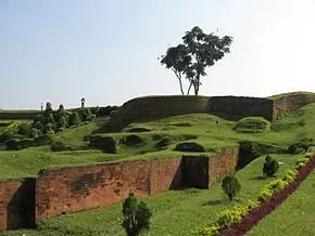
There are several archaeological sites in this city surrounded by walls. For centuries, this place was the capital of the mighty Maurya, Gupta, Pal and Sen rulers, and later the Hindu feudal kings. From the 3rd BCE to the fifteenth century, the kings of various Hindu kings and other religions ruled. The location of Mahasthangarh is in Shibganj upazila of Bogra district. [3] About 13 km from the city of Bogra The ruins of this city can be seen on the west coast of the Karatoya river.
Mahasthangarh border wall

source: google.com
History
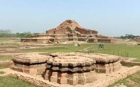
The famous Chinese traveler Hiuen Tsang came to Pundranagar between 639 and 645 AD. In the introduction of travel, he mentions the nature and way of life. Being famous for Buddhist education, monks from China and Tibet came to Mahasthangarh to study. Then they went out in different countries of South and East Asia. They went on to expand the teaching of Buddhism. [6]
source: google.com
This average was unprotected when Laksmanasen (1082-1125), the last ruler of the Sena dynasty, was king of Gaur. The King of Mahasthan was a tube whose conflict was with his brother Neel. At this time, a cursed Brahmin from at the place called Srikrityra in Dakshina, India, is here to atone for the sin. He was cursed for mother or daughter by a child or an ax. Later, he ended the dispute between these two brothers and became the King. This Brahmin's name was Rama. In history, he is known as Parshuram. According to legend he was a tyrant.
King Parasuram evicted and came to establish peace of Islam, the more spiritual fervent saint of Fakir Hazrat Shah Sultan Mahmud Balkhi (R :) and his followers. There is a miracle about religion propagandist Shah Sultan Balkhi (R). [7] It is said that he crossed the Karatoya river while entering Mahasthangarh in ancient Pundranagara, riding on a huge fish-shaped boat. On reaching Mahasthangarh, he was invited to Islam, firstly the Chief of Army Staff, Minister and some ordinary people of Raja Parasuram accepted Islam's message. [8] [9] Thus, when people of Pundravardhana accepted Islam from Hindu religion, King Parshuram fought with Shah Sultan's dispute and At one time Sultan Balakhi defeated Pundravaram (1205-120) in the last King of Pundravardhana, in Pundravardhana. He ়.

source: google.com
Geography
The location of Mahasthangad in the capital of Pundravardhana, 11 kilometers (6.8 miles) north of Bogra city, beside Bogra Rangpur highway. It is believed that here the main reason for building the city is because it is one of the highest regions of Bangladesh. This land is 36 meters (118 feet) high above sea level, in which the capital of Dhaka is just 6 meters (20 feet) high from the sea level. Another reason to choose this place is the position and shape of the Karatoya river. The river was three times as wide as the present Ganges river in the 13th century. [10] Mahasthangarh is located on the red soil of the Barind region, which is slightly elevated from the polygyny region. Top areas of 15-20 meters are considered as wild-free zones
Discovery
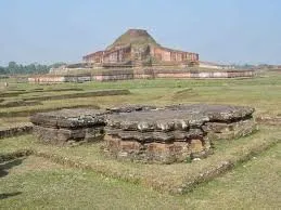
There are many people who contribute to the identification and discovery of the ruins of Mahasthangarh. In 1808 Francis Buchanan Hamilton first identified the location of Mahasthangarh. In 1879 British archaeologist Alexander Cunningham identified this ancient historical city as the capital of Pundravardhana. Many tourists and scholars, especially C. J. O'Donel, E. V.V. Westmacht and Henry Beveridge visited this suburban area and mentioned their report. Brahmi script found in archaeological excavation in 1931. Emperor Ashok, the provincial ruler of Pundranagar, ordered to give food and money assistance to the famine-stricken people from Rajvandar. These information data show evidence of the ancientity of this famous city
source: google.com
Fireplace
The staircase in the ancient city center was rectangular, which is 1.523 kilometers (0.946 miles) north-south and 1.371 kilometers (0.852 miles) east-west. There was a high and broad protective wall beside it. The area of the fort is approximately 185 hectares. [10] Prasusta river was flowing east of Karatoya. [2] Prior to excavation until 1920, the height of the fort was 4 meters above the adjoining area and several high grounds were painted. The defense is seen as a wall made of clay, which is seen in many places to break the force. The wall is 11-13 meters (36-43 feet) taller than the surrounding area. There was a tomb in the southeast corner of it. There is also a mosque built later (1718-19). Currently there are several mounds and construction patterns found inside the fort. Among them, Ziyat Kunda (a well that is believed to have the power of life), the step of Mankalari (the sacred place of Mancali), the house of Parasuram (the palace of Raja Parasuram), the Vairagir Bhita (the monks of the nuns), the stone stone of God (the stone vested to God) Munir Ghon (a clo), etc. are notable. There are several entrances in the various places such as the thorns (north), Darab Shah (east), the gate of the old (south), the gate of the gate (in the west). [2] In the north-east corner there are several steps (later attached) that went to Shajghatata. The Gobinda Vita (Govinda Temple) is situated on the banks of Karatoya in front of the shipyard. There are local museums in front of which there are significant signs showing. There is a rest house next to it.
City Infrastructure
In addition to the Durga Katha, there are about 9 km Spread across a wide area of radius.
Digging mound [2]
Govinda Vita, a temple situated in the north-east corner of the fort
The opening of the Khullar, a temple
Mangkalkot, one kilometer south or southwest of the Mahasthangarh Museum
Temple. [12]
Gadai Bari steps, 1 kilometer south of a temple in Khulna
The stage of the Totaram Pandit, an ashram located 4 kilometers northwest of the fort
The step of the president (Bhasu Vihara), 1km north-west from the stage of the Totaram Pandit
A cluster of monasteries
Gokul Medh, (Lakhindar Bastarghar), a temple three kilometers south of the fort
A temple, 2km south east of Gokul Medha, a temple east
Bairagir Bhita, found in the ruins of Bairagir in 1928-29, found the ruins of two temples
Goes.
source: google.com
Excavation
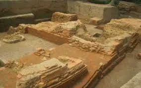
The Archaeological Archaeological Excavation of Mahasthangarh Archaeological Survey of India N. Under the supervision of Dikshit, first started in 1928-29. Then around Munir Ghon and Bairagir Bhita were visited around the ship. In 1934-36, the work of digging was stopped in Vairagir Vita and Govinda Vita. Brahmi script found in archaeological excavation in 1931. Emperor Ashok, the provincial ruler of Pundranagar, ordered to give food and money assistance to the famine-stricken people from Rajvandar. In the year 1960, excavation work was carried out near the shrine of Mazar, Parasuram, Manakali steps, Ziyat Kunda and the northeast wall. The posterior excavation work was carried out sporadically in the east and the north, where the final report was not published. [13]
The initial reports of these excavations were published in 1975. About two decades later, excavation was started in 1988, and by the year 1991, excavation continued for almost every year. At this time the excavation is limited to the adjoining area of the shrine and adjoining areas of the north and east. But the amount of work done at this stage was very small compared to the vastness of the area. The history and cultural order of this place are still unknown. It was felt for a long time that the need to conduct a comprehensive research to reconstruct the ancient history of this site and region and to become aware of the ancient city's organization. As a result, Bangladeshi and French archaeologists took a joint initiative in early 1993, under the agreement between Bangladesh and France (1992). From then onwards, archaeological excavation works in the adjacent areas of the eastern wall of the eastern wall. Excavations have been conducted by the Department of Archeology, Bangladesh, in the vicinity of Vishubihar, Bihar Stage, Mangalkot and Godai Bari, outside the protected city earlier. Excavation in the city has been excavated up to the main soil of the site at some places. Meanwhile, the recent excavation conducted by the France-Bangladesh Mission unveiled 18 construction blocks. The following cultural hierarchy has emerged as a result of excursions conducted from 1929 to today (including France-Bangladesh).
First period: At this stage there is a large number of North Indian black smooth pot, roulette pot, black and red pot, black plated pot, gray pot, stone stool, clay mud house (kitchen), as a reminder of pre-Mauryan culture. , Oven and cushion hole. The northern black smooth pot was found in the highest level at the lowest level. Among them, the dish, cup, glass and gumla are the main ones. A brick-built floor found in very limited areas at this level. But no walls related to the floor were found yet. Probably the settlement was first settled on Pleistocene lands. The top-level level radioactive carbon dates were found in the last part of the 4th century BC. From this, it can be assumed that the pre-Maurya era of this level settlement. It is necessary to determine whether this native settlement level is associated with Nand or almost historical culture.
Second era: Among the archipelages available in this period are Bhangaon Tali (the oldest typical tali used for such rooftops), brick pieces used for mixing or clamping the walls of the clay (occasionally in the housekeeping work, such as the place of the stove, the terracotta leaf), the northern black smelter, The common red or yellow yellow pallets, ring stones, bronze mirrors, bronze lamps, g u mca pour coins, terracotta plaques, terracotta animals, ardhamulyabana yata stone bead and stone. Some radioactive carbon dates (366-1612, 371-173 BC) and cultural products include this stage in the Maurya era.
Third period: This period includes posthumous postures (Shung-Kusana). In this era, significant architectural relics of bridges, brick-built floors, poles, terracotta plaques, humming terracotta plaques, semi-precious stones (apple carnelian, quartz) beads, silver cutting rods, strawn silver coins, silver bracelets, welding Plenty of copper coins, terracotta temples, pale red or yellow colors The amount of ordinary pot (especially dish, cup, bag) and gray ware have been found. The thicker black fabric of thick black fabric is less than this level compared to the monsoon. The level of caloric intake of some radioactive carbon is 197-47 BC, 60 BC-172 AD, 40 AD-172 AD BC
An ancient script found in the mausoleum

source: google.com
Fourth epoch: The Kusana-Gupta era has been unveiled at this time. Sufficient quantities of Kusana pottery pieces and typical classical typical terracotta plaques are the discovered archaeological sites of this era. The main type of pottery is hand-drawn cooking utensils, patches, gumla, peachcars and lid. Architectural relics are less in this part than the upper and lower levels. Brick pieces of architecture are broken bricks. Other cultural items are terracotta beads or beads, rubble, stone and glass beads or beads, glass bangles and terracotta seals.
Fifth Era: This age carries the identity of the Gupta and Gupta era era. The calorie date of 361 to 594 was indicated in the radioactive carbon method. At this stage, the ruins of brick-built buildings of the temple, and the ruins of brick-built homes, floors and roads found in the next Gupta period called Govinda Vita near the fort-city. In addition to this, there are a large number of architectural structures including terracotta plaques, seals, glasses and beads, terracotta spheres, discs, copper and iron products, and impressive designs.
Sixth Era: This period carries the identity of the Pala era by the stone sculptures of God, Manakalai's Kunda stages, Parasuram palace and Bairagir Vitra, along with some scattered archaeological ruins east of the city. This stage was the most prosperous and in this era many Buddhist buildings were built outside the city.
Seventh period: The ruins of the 15-domed mosque on the ruins of the ancient era in Manakalir Kund, and the identification of the Muslim age by the ruins of a dome-dominated mosque built by Farrukhsiyar and other ancient silhouettes such as the Chinese Saladan and the elegant clay potteries of this era. In the interior of the city, important archaeological sites have been discovered from the sites of Bairagir Vita, God's Stone Vita, Mankalir Dhibi, Parasuram Palace Dhibi and Ziyat Kunda. In addition to these sites, in 1988-91, excavation has established three entrances of the city, a significant part of the North and East Protecting Walls and a temple establishment near the mazar area.
Three gateways to the Mahasthan site are located in the north-facing defense wall. An entrance is 5 meters wide and 5.8 meters long, 442 meters east of the north-west corner of the fort. The other is located 6.5 meters east and 1.6 meters wide. The gateway was used for two early and next pala period. The only gateway to the eastern defense wall is located in its center and 100 meters east of Parasuram palace and about 5 meters wide. It is believed that it was built on the ruins of an old entrance at the end of the Pala era. The entrance is not yet fully recovered. All the entrance-rooms are equipped with an extended tower inside the guardroom and guarded wall.
No coherent construction plan can be observed in the temples in the mosque area. It appears that during Pal rule, it was built and rebuilt in five stages. The reclamations recovered from this area include some large-scale terracotta plaques, toys and spheres, and ornamental brick and clay pot.
The city's defense-wall is built in six stages. In the earliest period probably associated with the Mauryas and the next phase of Sung-Kusana, Gupta, Primary Pala, Next Pal and Sultanate period. These walls have been phased out on one another. Therefore, in addition to periodic cultural ruins inside the city, there is also a periodic phase of construction of the defense wall. However, the cultural relics of the city at the oldest level and correlation between the oldest defense wall still can not be ascertained.
Archaeological area excavated in the adjacent areas outside the city of Govind Bhita, Lakshmindar, Vashubihar, Bihar Phap, Mangalkot and Godai Bari Phap. But in the adjacent villages many other ails are scattered, where the cultural ruins of the sub-outs of ancient protected Pundranagara are believed to exist.
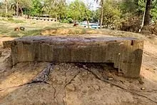
King Parshuram sacrificed on the stone
source: google.com
Sightseeing
Mahasthan Average is one of the oldest tourist centers in Bangladesh. There are many tourist attractions here. In 2016, several cultural programs have been organized in Mahasthangarh as the cultural capital of South Asia.
Notice to viewers
Mahasthangarh is located 11 km (6.8 miles) north of Bogra, on the Bogra-Rangpur Highway. A flowing stream of Karatoya river flows along the side. The road went to Jahaghatta and the museum. There is a bus to go directly from Dhaka and it takes about four and a half hours to go over the river Jamuna on the river Jamuna. Buses are also available from Bogra and there are rickshaws for local transport. In addition, rental cars are also available from Dhaka or Bogra. [14] Traveling in a rental car can be returned to the same route, or if you wish, you can visit Sompur Mahavihara in Naogaar Paharpur.
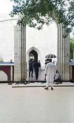
Mazar Sharif
source: google.com
Mazar Sharif of Shah Sultan Balakhi Mahisawar
According to many historians and local people, it is the shrine of Hazrat Shah Sultan Mahmud Balkhi (R :). The mazar Sharif is situated somewhat west of the Mahasthan bus stand. Shah Sultan Balkhi (R :) was an Islamic preacher of the 14th century. [7] He is said to be in a fish-shaped boat with his followers, in the varendra land. From there, his name comes from Mahisawar (the fish coming on the back of the fish) and he was the son of the king of the Balkh state, because he was called Shah Sultan Balakhi.
In 1680, Emperor Aurangzeb Syed Reza, Syed Tahir, Syed Abdur Rahman (three brothers) gave the responsibility of supervising the shrine as a custodian. The local people respected Shah Sultan Mahiswar. Hundreds of thousands of Muslims came to the shrine to solve and vow their problems.
The museum
Main article: Archaeological Museum, Mahasthan
Located 7 kilometers north of Bogra and slightly north of Mahasthangarh, opposite the Govinda Vita, this museum was established in 1967. Initially, if the main part of the museum is on 3 acres of land, it has expanded at different times and now its scope is about 10 acres.
Thousands of millions of memories of gold, silver, iron, bronze, stone, karsasaha precious metals, terracotta figurines, black stone statues, sandstone statues, made of mudra, Gupta, Pal, Sen and other dynasties due to mahasthana average excavation Engraved bricks, goldsmiths, various inscriptions, sharp weapons for self defense, essential utensils and various types of ancient alloys Contents, etc., were found in the museum in the north of the average. Besides the Mahasthan average, archaeological remains of more places are preserved here.
God's Stone Hut
Main article: God's Stone Vita
King Parshuram sacrificed on the stone
God's Stone is located in the hills before the Vita Mazar. This rectangular Buddhist temple was east-facing. It is long and square, which is generally not available in nature. It is believed that Raja Parshuram collected it and used it for slaughtering. Hindu women bathing with this stone milk and vermilion. Some people still pour milk on this threshold in nude legs and devote their devotion.
The ruins of this Vetra are known in the early part of Pal rule (approximately 8th century AD). In 1970, there was a temple excavated in the mound or the Bhita and some minor archaeological patterns along with it. A huge threshold of granite stone is found on the surface of this mound and this time the local people have made such strange names in the mound. Here are three statues of Buddha found in the same row in the same row of the engraved stone fragments found in excavation. Which is now preserved in Varendra Research Museum. The remains of the structures of the site are still buried under the ground. Only the huge threshold is seen here.
Mancali Dhibi

source: google.com
Main article: Manikali Dhibi
This temple was built by the great religious preacher Mokshalis Gosal. It is located east of the fun pond of Mahasthangarh. In the year 1965-66, excavation work was started under the supervision of the Department of Archeology, and in the end several small archaeological objects were discovered along with the ruins of a mosque in the Sultanate period. The mosque is 26.21 to 14.54 meters. During the excavation work, some ruins of a temple were found under the mosque. No inscription was found in the mosque, but archeologists thought that it was probably built before the Mughal period after seeing the structure of the mosque. According to legend, at this place, first a temple was built by King Mansingh and his brother Tansingh. According to other legends, the mosque here was built by zamindars of Ghoraghat. Apart from the Jaina idols here, many people think that the place was formerly inhabited by Jaina Dharmaguras.
Bairagir Bhita
Main article: Vairagir Bhita
Located in the north-east of Mahasthangarh, about 200 yards from the house of King Parasuram. The size of this stack is 300 × 250 feet.
Step step
Main article: Stepping step
This is the destruction of a temple. This step is located next to a pond about 50 meters east of pucca road, about 3 kilometers south of Mahasthangarh. In the 7th century AD, there was a temple of Kartik in Pudunagar, known in the Rajaratangini of the Pandit named Kalhan. It is believed that this temple of the scandal is the temple of Kartik. Many excavations have been done due to excavation.
Mangalkot stack
Main article: Mangalkot
Mahasthan is about 1 km to the west.
Gokul Medh
Gokul Medh

source: google.com
Main article: Gokul Medh
It is located 2 km away from Mahasthangarh to the south west corner.
Tangra Buddhist stack
This stack of about 45 ft height is located in Tangra.
Bihar Phase

source: google.com
Main article: Bihar Phase
It is located 6 km northwest of Mahasthangarh. The stack is 700 × 600 feet in size.
Bhasu Vihar

source: google.com
Main article: Vaasu Bihar
7 km from Mahasthangarh and north to west and located 2 km north of Buddhist monastery.
Jungle of vim
The three sides of Mahasthangarh are eclectic and numerous black-haired historic establishments, the jungle of this villa
Kalidah Sea
In the western part of the average there is the historic Kalidah Sea and the western part of the fort is located in the historic Kalidah Sea and Padmadevi. The historical average of the Kalidah Sea is surrounded by an earthen pot. Rarendi baths were held in the ancient Kalidah Sea every year in March of the Hindu religion. After the bath, the pilgrims organized the Gangapuja and Sankirtan programs at the sea level.
Shiladbeer Ghat
Main article: Shiladevir Ghat
'Shiladebari Ghat' on the banks of Karatoya river on the east side of the average. Shiladevi was the sister of Parshuram. Here every year Hindus get bitten and one day a fair sitting.
Ziyat kund

source:google.com
Main article: Jeet Kund
To the west of this ghat there is a big wing named Ziyat Kunda, which is one of the archaeological remains of Bangladesh. [16] It is said that the injured soldiers of Parashuram would be healed after drinking this water. Although no historical foundation was found.
Bihula Basar house

source: google.com
Main article: Gokul Medh
There is a Buddhist pillar that is believed to have been built by Emperor Ashok, about 2km southwest of Mahasthangarh bus stand. The height of the pillar is about 45 feet. In front of the pillar there is a 24-bath bath with a typical pond. It is also known as Behula Basar house. [17]
Govinda Bhita

source: google.com
Main article: Govinda Bhita
Gobinda Vita is situated right in front of the Mahasthangarh Museum. The word Govinda Vita means Govinda (Hindu deity) and Vishnu's house. A Vita is excavated in a digging site, 1928-29 and is located north of the Dug Palace area of Govinda Vita. But no evidence of Vaisnavism was found here. Yet the site is locally known as Govinda Vita.
Parashuram's palace

source: google.com
Main article: Parashuram palace
One of the ancient civilizations discovered inside the wall enclosure of the historic Mahasthangarh in the palace of Parshuram. Locally, it is known as the so-called Hindu authority Animal Husbandry Palace